  |
| HOME | THIS ISSUE | CALENDAR | PATENTS | BACK ISSUES | < BACK | NEXT > |
Remote sensing can provide evidence of genocide, says grad studentby Elizabeth Omara-Otunnu - March 30, 2009
|
||||
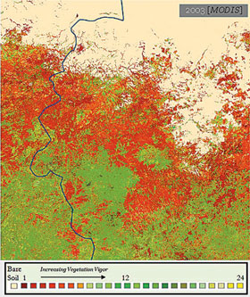
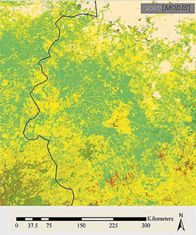
| Prosecutions for major human rights violations have increased in recent years, since the establishment of the International Criminal Court in 2002. But the most heinous crime of all – the systematic elimination of an entire race or ethnic group – has been difficult to prove. A UConn graduate student is developing a new form of evidence that would bolster the case against perpetrators of genocide. Russell Schimmer, who is simultaneously pursuing a Ph.D. in the Department of Natural Resources and the Environment in the College of Agriculture and Natural Resources and a J.D. at the School of Law, says images obtained through remote sensing techniques can provide evidence of genocide. Remote sensing, he explains, uses the physics of light reflectivity to study conditions on earth from afar, either through satellite images from space or through images taken from the air. “Everything on earth reflects light differently,” he says, “and that means remote sensing can detect the differences between objects.” Evidence of genocide He says that while the course of events in that area is generally known, specific information is hard to come by, because many of the witnesses are now dead and those still alive may be too intimidated to testify. In an effort to collect independent evidence, he has analyzed satellite images of the area showing changes to the landscape that corroborate what people on the ground have said. Darfur, he says, is primarily an agrarian society that since 2003 has been totally disrupted by systematic violence involving the burning of villages, stealing of livestock, and displacement of people. Schimmer hypothesized that these events would show up in changes to the landscape. Before the violence broke out, livestock accounted for up to 80 percent of Darfur’s annual income. Because of declining rainfall caused by climate change and an increase in the numbers of livestock, prior to 2003 the environment was under considerable stress, he says. By 2005, the genocide was underway and huge numbers of people had been killed or displaced and thousands of livestock looted or killed. Working from hundreds of satellite images available on the Internet, Schimmer compiled data on the extent of the areas under vegetation and the health of that vegetation from 1999 to 2007. Images from about 2005 clearly showed that, even though rainfall decreased slightly, the amount of vegetation rebounded dramatically once the livestock were gone. “It was amazing. Both temporally and spatially, the images matched what was already known,” he says. “Is this proof of genocide?” Schimmer asks. “How else do you explain it? It shows there’s been a major change in population distribution, and corroborates what we know happened on the ground.” He says the reason he is studying law is to try to make this type of data more acceptable as admissible evidence in international courts to show that genocide has occurred. Genocide is hard to prove, he says. For judicial purposes, the prosecutors of genocide perpetrators must prove widespread and systematic acts intended to destroy a particular group.
The images of Darfur clearly show changes that were widespread, he says, and there is no other target group in the area. But in order to demonstrate that the acts were systematic, he plans to use corroborating evidence from another part of the Sudan. During the late 1980s and 1990s, he says, in an area just east of Darfur, a different nomadic group was used to remove people from the land in a similar way to the Janjaweed in Darfur. Once the land was cleared, the government sold it for oil concessions. “If we can demonstrate the same pattern – with images that show the normalized situation before the violence, changes in land cover as a function of land use and climate the moment violence begins, and the perpetuation of those changes even after the violence is over – we can say there’s a system here,” he says. “There are the same three kinds of steps.” Most of Darfur, Schimmer notes, has not yet been subject to oil exploration. Need for transparency Schimmer also analyzed images from a French government-sponsored satellite to cross-check his findings. He says using publicly available information creates a transparency that is an advantage both in research and in the sort of international legal applications he envisages, where the data may be used in highly politicized situations. Although related, Schimmer’s genocide research is not the focus of his Ph.D. For his doctorate, he is using remote sensing to study the environmental and human impact of large-scale mining. Schimmer says his passion for human rights comes from his family background. His father grew up in Holland under Nazi occupation and was a prisoner of war during World War II; his mother grew up in Puerto Rico and immigrated to New York City. “My interest in human rights came from people who lived their lives trying to create change,” he says, “who were willing to take on adversary forces but create change peacefully.” Schimmer will give a presentation on his work titled “Genocide, Environment, and Agricultural Sustainability, on Sunday, April 5 at 3 p.m. in Room 130 of the Biology/Physics Building, as part of the Natural History of Food lecture series. |
| ADVANCE HOME UCONN HOME |


