  |
| HOME | THIS ISSUE | CALENDAR | GRANTS | BACK ISSUES | < BACK | NEXT > |

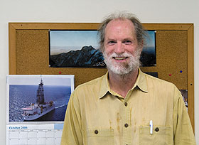
Geologist joins international study of earthquakesby Cindy Weiss - November 5, 2007 |
||||
| A UConn geologist has joined a scientific expedition off the southwest coast of Japan to learn more about what causes earthquakes, knowledge that someday could be used in disaster management. Tim Byrne, a geologist and associate professor with the Center for Integrative Geosciences in the College of Liberal Arts and Sciences, has joined what he described as a “floating University” on a Japanese drilling ship poised over the Nankai Trough Seismogenic Zone. The 20-30 scientists aboard the ship Chikyu (“Earth” in Japanese) are part of a long-term expedition that will take seismic images, examine the composition of sediments, collect core samples to study, position sensors on the ocean floor, and search for faulting zones. There are thousands of earthquakes every month in Japan, Byrne notes, many of them minor. The area where he is working has not had a major quake in more than 60 years, although it is prone to them. The Nankai Trough is between the Asian and Philippine Sea plates and is one of the most active earthquake zones on the planet, according to the Japan Agency for Marine-Earth Science and Technology, the leading marine-earth science research institute in Japan. The expedition is part of a worldwide, scientific Integrated Ocean Drilling Program supported by the U.S. National Science Foundation, Japan, the European Union, and other participating countries. The goal is to explore the geology below the ocean floor and study the processes that ultimately cause violent, unpredictable earthquakes. “Ultimately our dream is to identify precursors,” says Byrne. Learning more about the warning signs of an earthquake could lead to earlier warnings and damage prevention. Byrne will spend six weeks on the drilling ship off Japan at this stage of the expedition. In early 2009, he will be a co-chief scientist on another three-month stage of the work. After all the shipboard work is done, scientists will be able to monitor the Nankai Trough from land, collecting data by cable from instruments planted on the sea floor during the research cruises. The Japanese government has invested heavily in earthquake research and instrumentation, Byrne says.
Byrne will be looking for areas along the plate boundary where there are seismic gaps – where elastic strain is accumulating, and for fault surfaces, where two areas of rock slip past each other. An earthquake results from a build-up of elastic strain, and there might be “micro-earthquakes” preceding it, he says. The ship has a drilling rig that will lower plastic pipes to the sea floor, where they will collect samples that can then be analyzed on board. It can take 24 hours to lower a pipe to the sea floor. Scientists work in 12-hour shifts to analyze what comes up. “It’s pretty intense,” says Byrne. Successive stages of the expedition will drill deeper, until samples are collected 5,000 to 6,000 meters or more beneath the sea floor. Oil companies, in contrast, dig down to about 3,000 or 4,000 meters. Byrne was chosen for the expedition because of his expertise in the geology of Japan, where he had a fellowship in 1990, and in making field observations in areas where geology is actively evolving. Last year he spent a sabbatical leave on a Fulbright grant in Taiwan, where he climbed into areas accessible only by foot to map faults in the southern mountains, another geologically active and earthquake-prone area. Hear a podcast about Byrne joining the expedition off Japan. |
| ADVANCE HOME UCONN HOME |