For more archives, go to the Advance Archive/Search Page.
Civco’s Students Learn How to
View the World From Above
Variations in aerial photography are endless, from a child pressing a throwaway camera against the Plexiglas window of an airliner to a space shuttle astronaut giving mankind a stunning view of the world.
Explaining the science behind aerial photography is Dan Civco’s specialty.
Using everything from an aerial view of a mansion owned by basketball star Michael Jordan’s to the IMAX movie Blue Planet, Civco, an associate professor of natural resources management and engineering and one of this year’s University Teaching Fellows, engages his students in a lively discussion about how images are captured and analyzed.
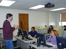 |
Daniel Civco, University Teaching Fellow, discusses geospatial data processing techniques during a class in the Young Building. |
Civco’s discipline is called geomatics, which includes remote sensing via such technologies as aerial photography and GPS, the global positioning satellite system. Birds of prey “remote sense” when they look down in flight, visually acquire a target, and dive. Humans do it when they gaze across an expanse and record an image, however briefly, in the mind’s eye.
The concept becomes more complex when humans behave like birds and take to the sky and beyond to study Earth’s features using satellites, aerial photography, lasers, radar, and other sensors. That’s where Civco and his students come in, using geomatics mainly to understand how such natural phenomena as marshlands, forests, and other types of terrain are changing over time.
Armed with at least some background in physics, geometry, geology, math, and statistics, the students in Civco’s introductory class and lab dissect aerial images, demonstrating that there’s more to them than meets the eye.
For example, Michael Jordan’s mansion is impressive to a casual observer, but to Civco’s students, the real relevance is the angle from which it was photographed, or what technique might be used to determine how far the tennis courts are from the swimming pool.
Not long ago, the subject in Civco’s class was “horizontal geometry” and how camera focal lengths affect scale. Using an overhead projector and a few dozen slides that he continued to tweak right up to class time, he paced back and forth, posing questions, offering equations, and occasionally admonishing students. For example, “Let me suggest or encourage … no, let me require that you put the units of measurement in your equation, so we know what it is that equals what.”
Civco insists that students be well grounded in the principles and concepts that govern his discipline. It would be easier, he says, to give students a formula and tell them to plug in certain numbers to achieve a solution to an aerial imagery puzzle, but that kind of short cut would be akin to using an automatic camera in lieu of manually setting f-stops and shutter speeds.
The students respond well to his style and, as one put it, “his passion.” Although Civco is apprehensive about “report cards” from students, his post-semester evaluations are generally high. And when his nomination as a Teaching Fellow was under consideration, former students were enthusiastic.
“Dan does a superb job, both as a teacher and advisor,” one said. Another cited his “infinite patience and ability to explain complicated concepts in a manner that inspires his students.” A third said, “His preparation for classes, teaching methods, and knowledge of the subject matter are worthy of the highest recognition.”
Civco, who once had enough leisure time to rank as a low-handicap golfer, now finds that there is not enough time to cover all his teaching aspirations. He typically hones lesson plans over the weekend, and says he has little time for recreation.
Civco and his students look primarily at how remote sensing can illuminate changes taking place in the terrain. But remote sensing is also used to study population density, global warming, transportation and water use, and for military surveillance.
One of history’s most public looks at a remote sensing application came during the Cuban missile crisis of 1962. Skills similar to those Civco teaches today were used in rudimentary form by analysts then to verify the threat faced by the United States.
“Sometimes I get calls from former students who do classified government work,” Civco says. “They ask me questions but are always careful not to reveal exactly what it is they’re talking about.”
He adds, “One of the most satisfying aspects of my career is seeing students evolve and become engaged professionally in and make substantial contributions to the field. When they are successful and enjoy what they do, that makes me happy … and proud.”

