For more archives, go to the Advance Archive/Search Page.
Archaeological Site Maps To Be Digitized
When construction threatens the archaeological heritage of the state - whether it is the remains of a Native American campsite in Coventry, a 1725 church and burial ground in Fairfield, or an 1880 farmstead in Greenwich - the first step that State Archaeologist Nicholas Bellantoni takes is a review of the state archaeological site files in his office, to study relevant paper maps and documents.
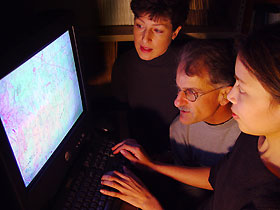 |
Anthropology graduate student Jaime Grant, right, demonstrates to Leanne Harty, director of the Connecticut
State Museum of Natural History and Connecticut Archaeology Center, and State Archaeologist Nick
Bellantoni, a Geographic Information Systems program that will computerize state archaeological site files.
Photo by Jordan Bender
|
Thanks to a new collaboration with UConn's geography and anthropology departments, UConn graduate students, the State Historic Preservation Office, and the Friends of the Office of State Archaeology, the Connecticut State Museum of Natural History and Connecticut Archaeology Center are undertaking a project to computerize the site files.
Collaborative work on Geographic Information Systems (GIS) and archaeology, with others at UConn and with state agencies, will complement the geography department's research and teaching activities in GIS, says William Berentsen, professor and head of the geography department. The department has a national reputation for its use of GIS in a wide range of research projects.
"It is especially gratifying for geographers with interests in land use and settlement to see new technology being used to help rediscover and preserve the record of Connecticut's early inhabitants," Berentsen says. "The collaboration will help our students and will help UConn serve the state in our role as Connecticut's land grant university."
Leanne Kennedy Harty, Director of the Museum and Archaeology Center, says that without help, the project could not be undertaken at present.
"The project will rely heavily on the expertise of students to provide more comprehensive management of information to preserve the 5,000 known archaeological sites in Connecticut, many of which are vulnerable," she says. "Their efforts will greatly increase accessibility for researchers and federal, state, and local officials, and it will speed the work of the State Archaeologist, who provides hundreds of technical assessments to municipalities each year."
Bellantoni generally has only 30 days to assess a construction project and make recommendations that often lead to field reviews and negotiations. In thousands of cases, however, he has been able to work successfully with towns and developers so that the development can take place without destroying archaeological sites.
Bellantoni says it will be much quicker to retrieve computerized data than having to go through 5,000 paper maps and site files. "We'll generate data and town-wide or other types of maps, update our files as new sites become known, and do predictive modeling using statistical correlations of environmental and cultural data," he says. "At a minimum, the computer will reduce our initial work from hours to minutes."
When construction is proposed for a site that has not had a previous archaeological evaluation, predictive modeling will enable Bellantoni to predict the likelihood of the presence of an archaeological site and take action.
"For example, if we have results that show that 90 percent of all known Woodland Period archaeological sites are located in a flood plain, have soils within 100 meters of fresh water, and have 20 foot knolls, then we can make a more compelling case that the proposed construction site fits those correlations than one based on smaller amounts of data," says Bellantoni. "We're not against development, but we want to save archaeological sites wherever possible."
The project is estimated to take a year, as the 5,000 paper files hold extensive data.
"Connecticut Archaeology Center site files show what kind of site it is, what period it is dated to, who excavated the site and when, and what was recovered. The new system will allow us to add, access, and sort data quickly, which benefits our research," says Jaime Grant, a graduate student in anthropology and research assistant to the State Archaeologist, who will help set up the new system.
"With the new technology, we will be able to layer existing environmental maps over those of the Connecticut Archaeology Center to predict where currently unidentified sites are likely to be located," she says.
Some indicators that a prehistoric archaeological site may exist include elevation; distance to a permanent water source such as a river or pond; the slope of the land, because most prehistoric sites were located on land that is relatively flat or has a gentle slope; vegetation; and geology, such as an outcropping where people might have created a rock shelter sometime in the last 11,000 years.
The State Historic Preservation Office shares the files with the Archaeology Center and will provide a printer to make copies of large maps. The Department of Geography has offered scanning and software technology, and the Friends of the Office of State Archaeology donated a new computer to the project.

