This is an archived article.
For the latest news, go to the
Advance Homepage For more archives, go to the Advance Archive/Search Page. 
| |||
|
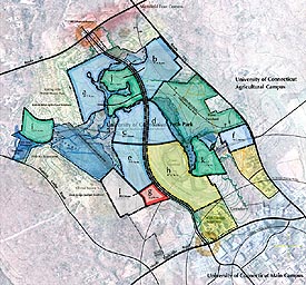
Growth of the Storrs campus will focus on 333 acres north and west of the main campus that can be used for a new technology-research neighborhood, says a campus plan approved recently by the Master Plan Committee.
The site, which includes mature trees and large areas to be preserved for environmental and aesthetic reasons and for recreational uses, is ideal for development of research-related activities, additional student apartment style housing, parking, and athletic facilities, says the plan, which was prepared by SmithGroup JJR of Ann Arbor, Mich. "The north campus presents the greatest opportunity for both careful site development and components of natural preservation," say the consultants. The parcels in north campus allow UConn to introduce technology-research as a primary land use, and to preserve 47 acres or more of prime farmland. "Many of the planning recommendations are geared specifically at preserving as many of the woodlands, wetlands, streams, steep slopes and primary farmlands as possible," the report says. "This is an important - and exciting - next step in the development of the Storrs campus," says Karla Fox, associate vice chancellor and co-chair of the Master Plan Committee. "The plan allows us to grow in alignment with the strategic research interests we have identified, and provides for planned growth." The plan includes suggestions for "outlying parcels" of land in three areas: the agricultural campus, the Depot Campus, and north campus, formerly known as the UCEPI land. Prepared by the same firm that completed the campus master plan four years ago, the latest plan has been in development since last fall and was overseen by the 40-member Master Plan Committee. The committee includes town and regional planners, students, trustees, faculty, staff, administrators and alumni. The new plan followed the same planning principles as the main campus plan:
Development of the north campus area is dependent on continuation of North Hillside Road, formerly known as ConnTech Road, which will run between Route 44 and the North Parking Garage. The road will take pressure off Route 195, Fox says, and will become the basis of new initiatives, including parking. Adding parking in north campus will free W lot, off Route 195, for other possible uses, and will provide access for research facilities that could be built in the north campus neighborhood. The area is also ideal for 1,000 to 1,200 beds of apartment-style student housing, and for the development of a multi-purpose athletic complex, including baseball, football and soccer fields. The housing proposed is in addition to 1,000 to 1,500 beds of apartment-style living planned in the Hilltop area. The plan also suggests that north campus is ideal for a faculty retreat center, nature center, or environmental research station, and for bikeways, pedestrian paths, and a small neighborhood retail area. Plans for the Depot Campus could include public-private partnerships, and potential non-university uses on parcels that are separated from the campus by topography and adjacent to Route 32. Development of the campus depends on simplifying the system of roads, improving road linkage to Route 44 and upgrading Bonemill Road, which is not owned by the University. The Depot Campus, located two miles from the main campus, consists of 300 acres formerly used as a state hospital for people with mental retardation. The site is "unusually attractive," says the plan, although "existing buildings are haphazardly arranged on the property, with no clear orientation to one another. This arrangement hampers the ability to establish a clear overall organizational concept ... (and) does not allow for creation of a well defined open space system, sense of scale, hierarchy or good orientation, all of which are important in establishing a comfortable campus plan." After removing buildings that have deteriorated, there will be 22 buildings previously used for housing, eight "institutional" buildings, and six "service function" buildings. Plans outlined for the agricultural campus include preservation of viewscapes on Horsebarn Hill, preservation of the University forest, space for active and passive recreation, and space to allow for the expansion of the existing facilities - some of which, the plan notes, are outdated and need replacement. "What is so nice about this plan is that it provides for rational growth," says Fox. "Over time we will be able to develop those areas that we have identified as strategically important to the University and its future." Karen A. Grava 
|