|
This is an archived article.
For the latest news, go to the
Advance Homepage For more archives, go to the Advance Archive/Search Page. 
| ||
|
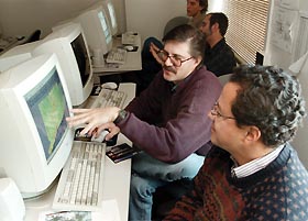
Or one that would show elected officials and local land-use commissions the current landscapes of Connecticut towns and the effects of zoning changes across town boundaries. Or one that would provide conservationists, property owners and nonprofit groups views of state watersheds, highlighting the tradeoffs between land use and resource protection as Connecticut's rural areas face increasing development pressures. This map exists. Connecticut's Landscape was recently created by a team of UConn scientists and educators, and presented as a poster to all the state's elected officials and state school systems last month. The poster-map shows the distribution of 28 land use and land cover categories for the state through computer-assisted classification of satellite images. "As a picture, the map is a striking look at the surface of Connecticut, depicting our mosaic of urban, suburban, forest and agricultural land in gradations of color," says Chester L. Arnold Jr., a water quality educator for the Cooperative Extension System, and a member of the NAUTILUS project team that created the map. "As research, it is a product of cutting-edge techniques used by UConn scientists to interpret our landscape from satellite data, a process known within the laboratory as using 'remote sensing' data to derive land use and land cover information." NAUTILUS - Northeast Applications of Useable Technology In Land Planning for Urban Sprawl - is a new NASA Regional Earth Science Applications Center (RESAC) located at UConn. Earlier this year the national space agency, seeking to create "real world" applications of remote sensing data, chose UConn's College of Agriculture and Natural Resources as home to one of seven new centers established around the country. The agency has made a three-year commitment of $1.1 million to the new center. The UConn center is an expansion of two award-winning University projects that have been working together for nearly a decade: the Laboratory for Earth Science Information Systems (LERIS) in the Department of Natural Resources Management and Engineering, and the Nonpoint Education for Municipal Officials Project (NEMO), part of the Cooperative Extension System. LERIS has created cutting-edge remote sensing data analysis techniques oriented toward natural resources and the environment. NEMO fashions remote sensing data into effective educational programs for local officials. The focus of the new center is sprawl and its impact on natural resources - particularly water and forest resources. It's a critical topic, at a time when the environmental, economic and social costs of the country's post-World War II pattern of development are becoming the subject of hot debate in the national political arena. "A satellite picture shows a lot," explains Daniel Civco, an associate professor of natural resources management and engineering and director of LERIS. "Our goal is to make the power of images made from remote sensing technology available and accessible to land use planners and decision makers concerned about the impacts of sprawl on their communities." To take a "picture," sensors on satellites collect the reflected solar energy that is bouncing off features on the earth's surface, Civco says. Different amounts and wave lengths of energy are reflected from different types of materials. For instance, water reflects solar radiation very differently from an urban area, and coniferous trees reflect differently from deciduous trees. Interpreting the information collected by satellite sensors is done on computers, with the aid of specially designed software using a technique called image processing. The data used to prepare Connecticut's Landscape were acquired by remote sensing equipment on board two satellites: Landsat 5, launched by NASA and now managed by Space Imaging Inc., and the French government's Système Probatoire d'Observation de la Terre. The NAUTILUS project uses these varied satellite remote sensing data, as well as high resolution airborne digital imagery, in its land cover mapping research and applications. To make Connecticut's Landscape, the NAUTILUS team also had to develop a technique that merged the data into a composite. The team further manipulated and displayed the data using mapping technology known as geographic information systems, or GIS - sophisticated computer programs that link information in databases to a map. A click on any reference point on the Connecticut Landscape map will bring up as much information as the system knows about that point - population density, primary vegetation, zoning regulations, for example, all of which can be shown visually. "GIS lets users compare seemingly unrelated data to see whether there's a pattern," Civco explained. "For planners, this helps provide them a broader perspective - a step back from their neighborhood focus - to consider multi-town issues, like watershed protection and habitat fragmentation." As part of the NAUTILUS project's goal to get the Connecticut Landscape poster-map into the hands of a wider group of potential users, Civco and his research team are posting town-level maps on the Web that can be downloaded. Future plans include making these maps not only Web-accessible but truly interactive, so that even the casual Internet user with no knowledge of remote sensing or GIS can "explore" with the data and construct a map to suit their particular interests. For more information about the Connecticut Landscape poster-map or NAUTILUS visit http://resac.uconn.edu. David Bauman 
|
 magine a map that would let UConn researchers "fly" over Long
Island Sound to measure the amount of nitrogen and phosphorus
entering the waterway from runoff, or estimate the uptake of
carbon dioxide by the state's forests.
magine a map that would let UConn researchers "fly" over Long
Island Sound to measure the amount of nitrogen and phosphorus
entering the waterway from runoff, or estimate the uptake of
carbon dioxide by the state's forests.